
CLICK TO VIEW Original Article by 92 Energy
Bryson Drilling Wraps Two Drill Program with 92 Energy in Athabasca Basin
The Athabasca Basin Unconformity Related Uranium Deposits Are Some Of The Largest Uranium Deposits In The World
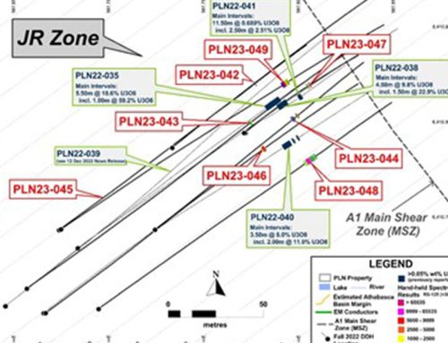
92 Energy’s five uranium exploration projects, Gemini, Tower, Clover, Powerline and Cypress River are located in the Athabasca Basin district, Saskatchewan, Canada (refer to Image 1: Athabasca Basin: 92 Energy Project Areas).
The Athabasca Basin hosts some of the highest grade and lowest cost uranium deposits in the world including the famous Cigar Lake, McArthur River and the more recently discovered Arrow, and Triple R. These deposits are all high grade unconformity-related deposits, of which there are two main sub-types (1) unconformity (Cigar Lake) and (2) basement hosted (such as the Arrow deposit). Saskatchewan, Canada, has been voted the third best mining and exploration jurisdictions in the world by the 2020 Fraser Institute Survey. This makes it a premier location in which to do business. All of 92 Energy’s projects were selected using its proprietary prospectively model over the Athabasca Basin.

GEMINI PROJECT
Gemini Mineralised Zone (“GMZ”) Uranium Discovery
The Gemini Project (Gemini) is an early-stage unconformity-associated uranium exploration project located on the eastern margin of the Athabasca Basin, 27km southeast of the McArthur River uranium mine, 60km northeast of the Key Lake uranium mill and 780km northeast of the regional centre of Saskatoon. Gemini consists of 13 granted mineral claims with a total area of 445.3km2. Gemini includes the recently discovered Gemini Mineralised Zone (“GMZ”) which is a near surface basement hosted uranium discovery.
The Gemini Project straddles the eastern margin of the Athabasca Basin. In the eastern and north-eastern parts of the project area the unconformity between the Athabasca Basin and underlying crystalline basement rocks is shallow and typically buried beneath glacial sediments or is completely absent. The unconformity is interpreted to dip gently to the northwest and may reach depths of up to 170m in the western part of the Gemini Project. Historic prospecting and surface mapping at Gemini identified numerous radioactive boulders, lake sediment and muskeg samples (up to 663 ppm uranium) in the southern part of the project area indicating a radioactive source up-ice direction to the northeast.
During the summer of 2021, drilling by 92 Energy targeted VTEM conductors up-ice direction from the historic radioactive samples identified on surface. On its 4th drillhole ever as a Company, GEM-004 intercepted 5.5m of 0.12% U3O8 (1,200 ppm) including 1.0m of 0.28% U3O8 (2,800 ppm). Since this discovery hole 92 Energy has carried out a winter-22 drill program (Feb-April 22) and summer-22 drill program (July -Aug 2022). With 91% of holes intersecting mineralisation during the winter-22 drill program and 81% of holes intersecting uraniummineralisation during the summer-22 drill program (Refer to ASX releases below).
The uranium mineralisation at the GMZ is basement hosted, starting at approximately 60m vertically below surface to 220m vertically below surface, and is associated with a broad and strong zone of bleaching, clay and hematite alteration controlled by fault breccias and other structures.
GMZ Uranium Discovery ASX Releases:
– 92 Energy Extends Gemini Summer Drill Program – 26 July 2022;
– 92 Energy Intersects Near Surface Uranium Mineralisation at the GMZ – Starting at 60m below surface – 25 July 2022;
– Final Winter 2022 Assay Results – 18 July 2022;
– 92 Energy Intersects 41.8m of 0.5% eU308 (incl 6m at 2% eU308) at the GMZ Discovery;
– 92 Energy Intersects Strongest Mineralisation to Date at GMZ Uranium Discovery, incl 26,100 Max CPS;
– GMZ Uranium Discovery – Assay Results Presentation;
– 92 Energy Intersects 17.0m of 0.38% U3O8, including 1.0m of 1.06% U3O8;
TOWER PROJECT
The Tower Project Is Only 10km From Cigar Lake Which Is One Of The Largest And Highest Grade Uranium Deposits In The World
The Tower Project (Tower) is an early-stage unconformity-associated uranium exploration project located in the eastern Athabasca Basin, 12km southeast of the Cigar Lake uranium mine, operated by Cameco Corporation, and approximately 820km northeast of the regional centre of Saskatoon.
The Tower Project consists of two granted mineral claims with a total area of 63.0km2. The Tower Project is located well within the Athabasca Basin and overlies Wollaston Domain crystalline basement rocks. The interpreted vertical depth to the unconformity in the project area is expected to be approximately 250m. Only four historic drillholes have been completed on the Tower Project to date.
The historic drilling was conducted between 1979 and 2015 and primarily targeted magnetic lows in the south-eastern corner of the project area, which were interpreted to reflect prospective metasedimentary rock units. The most recent geophysical work was undertaken in the mid-2000’s and consisted of EM and magnetic surveys.
The Tower Project is considered by the Company to be underexplored, with potential to host high-grade unconformity-associated uranium mineralisation. During the summer of 2021 92 Energy undertook airborne VTEM and magnetic surveys over the Tower Project. Planning of additional ground geophysics as well as diamond drilling is currently underway.
Drilling will commence on Tower in September 2022.
– 92 ENERGY TO DRILL 1,500M AT TOWER URANIUM PROJECT

CLOVER PROJECT
The Clover Project Has A 40km EM Graphitic Conductor With Only Three Drill Holes To Date
The Clover Project (Clover) is an early-stage unconformity-associated uranium project located in the eastern part of the Athabasca Basin, 30km northwest of the McArthur River uranium mine and 35km west of the Cigar Lake uranium mine (both operated by Cameco Corporation) and approximately 780km northeast of the regional centre of Saskatoon.
The Clover Project consists of six granted mineral claims with a total area of 267.5km2.The Clover Project is located well within the Athabasca Basin and overlies Wollaston Domain basement. The interpreted depth to the unconformity in the project area is expected to be between 450 to 850m.
Only three drillholes have been completed on the Clover Project to date, all by previous explorers. Numerous historic airborne and ground EM surveys including gravity, EM and magnetics have been undertaken on the Clover Project.Planning is underway for a ground geophysical program consisting of EM and resistivity at Clover.

POWERLINE PROJECT
The Powerline Project Has Numerous Uranium Occurrences And Little Exploration Activity Since The 80s.
The Powerline Project (Powerline) is an exploration project targeting unconformity associated and/or Beaverlodge style uranium mineralisation. The Powerline Project is located 2.5km west of Uranium City and is within 10km of 12 past producing uranium mines.
The Powerline Project consists of eight mineral claims with a total area of 205.3km2.The Powerline Project overlies the Zemlak and Beaverlodge Domains which are comprised of granites, amphibolites, orthogneisses, metasedimentary rocks as well as Martin Group sediments. The Powerline Project also partially overlies the significant northeast trending Black Bay Fault.
The Powerline Project was explored extensively between 1950 and 1980 through prospecting, trenching, diamond drilling, airborne and ground geophysics, and geochemical surveys, including basal till and lake sediment sampling. Numerous radioactive showings have been discovered on the Powerline Project including the Beta-Gamma Uranium Mine (SMDI #1394).Minimal uranium exploration has occurred on the Powerline Project in the last 15 years.
Ground geophysics and geological mapping to aid in drill targeting is currently being planned by the Company for Powerline, scheduled for late 2022.

CYPRESS RIVER PROJECT
The Cypress River Project Has Numerous Uranium Occurrences
The Cypress Project (Cypress) is an early stage project exploring for unconformity-associated and/or Beaverlodge style uranium mineralisation. The Cypress Project is located 13km west of the northern settlement of Camsell Portage and 840km northwest of the regional centre of Saskatoon (refer to Image 6: Map of Cypress Project Area).
The Cypress Project consists of one mineral claim with a total area of 34.7km2.The geology underlying the Cypress Project is dominated by granite, orthogneiss and metasedimentary rocks of the Zemlak Domain. No outcropping Athabasca Supergroup rocks are preserved in the Cypress Project area, but the unconformity is believed to occur in the southern part of the project area, beneath Lake Athabasca.Uranium exploration at Cypress was initiated in the 1950s.
Early work included prospecting, an airborne radiometric survey and an airborne EM survey (INPUT), as well as ground geophysics and geological mapping. This work led to the discovery of multiple radioactive occurrences along the shore of Lake Athabasca within 92 Energy’s claim including the Beach Zone (SMDI #3644) and Beach Zone West (SMDI #3645).
Minimal uranium exploration has occurred on the Cypress Project in the last 15 years. Geological mapping and prospecting to aid in drill targeting is currently being planned by the Company for Cypress, scheduled for late 2022.
